
Groundwater divining on your mobile phone
The Australian Groundwater Insight has been updated with 2014–15 data and new features, making it easier to find for government, policy developers and the general public to access and understand groundwater information.
Part of the Bureau’s Groundwater Information Suite, Australian Groundwater Insight has a mobile-friendly map portal integrating physical information on hydrogeology, groundwater levels and salinity analysis with management information on the locations of licensed groundwater entitlements, stock and domestic bore density and management areas.
For example, a farmer wanting to find groundwater information on their property could use the Insight to look up details on groundwater salinity, levels and management using the GPS-enabled ‘find me’ functionality.

‘Find me’ allows you to locate groundwater resources
while you are out in the field.
Groundwater level and salinity analysis maps showing 5-, 10- and 20-year trends offer insight into short and long-term fluctuations in groundwater levels and spatial variations. The status analysis compares the current groundwater level to the 20-year average level.
Examining both trend and status data together is a powerful way to understand aquifer behaviour. For example, an aquifer may have below-average groundwater levels but a rising trend, indicating it is recovering after a period of decline.
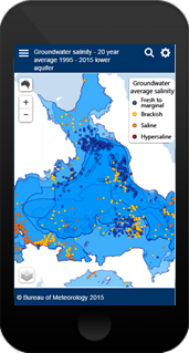
Maps showing average groundwater salinity for the past 20 years and salinity change over the past 5 years are also available, providing information about the quality of groundwater across the country.
Features in the 2016 release include:
- Groundwater salinity—valuable information about groundwater quality across the country. Long-term salinity data is available for more than 16 000 bores. Recent changes in salinity are also presented where data exists. These maps show how groundwater quality varies by location and aquifer, across Australia.
- Murray–Darling Basin Authority sustainable diversion limit (SDL) resource units included. Diversion limits in these areas do not come into force until 2019; however, this information gives context to the current management, and shows how and where management volumes may change in the future.
- Groundwater level and status datasets for 2014–15. Previous years’ data can be selected from a drop down button in each menu. This allows trends for different periods to be compared within the Insight.
- Additional contextual information, such as rivers, are available from the map layers menu.
Find out more about the Australian Groundwater Insight
Original article available in enGauge (Bureau of Meteorology), August 2016 (Link)