
New global 1 km resolution Köppen-Geiger climate classification maps
New present-day and projected future global Köppen-Geiger climate classification maps at a 1 km resolution are now freely available via http://www.gloh2o.org/koppen/.
The present-day (1980–2016) map uses topographically corrected climatic maps as input. The projected future conditions (2071–2100) are derived from an ensemble of 32 CMIP5 climate model projections (scenario RCP8.5), by superimposing the projected climate change anomaly on the present-day high-resolution climatic maps.
For Australia, future projections show that the Tropical savannah class extends much further down the east coast of Queensland. Additionally, the Arid, steppe, hot class is simulated to extend further south, and the Arid, desert, cold class is expected to disappear on the southern extent of the central arid region.
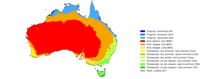
The data for the entire world is available at 0.0083° resolution (essentially 1 km) and this is a vast improvement over three recent world maps of the Köppen-Geiger climate classification being: (i) Kottek et al.’s (2006) map at 0.5° (or ~50 km) resolution); (ii) Peel et al.’s (2007) map with 0.1° (or ~10 km) resolution; and (iii) Kriticos et al.’s (2012) data with 0.083° (or ~8 km) resolution. The new maps provide a greater level of detail and accuracy than previous maps, particularly in topographically heterogeneous landscapes. Additionally, uncertainty maps associated with both the present-day and projected future conditions are provided.

Present day (1980-2016).
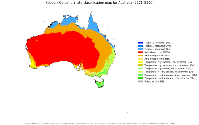
Projected future conditions (2071-2100).
Reference: Beck, H.E., Zimmermann, N.E., McVicar, T.R., Vergopolan N., Berg, A. and Wood, E.F. (2018) Present and future Köppen-Geiger climate classification maps at 1-km resolution. Scientific Data. 5:180214, doi:10.1038/sdata.2018.214.