
Satellite eye on Australia’s vegetation
The impact of TERN’s collaborative, multi-scale, and national approach to ecosystem science is once more on show this month, with the release of a new National Biomass Library, National Biomass Map, and landmark high-resolution map products of woody vegetation height and cover, via TERN AusCover. These products result from a combination of national and international collaborations, drawing field and satellite data from across TERN’s network, to deliver more accurate and finer resolution information on the state of Australia’s information, as a game-changing platform that can assist research, management, policy, restoration and sustainable use of Australian ecosystems.

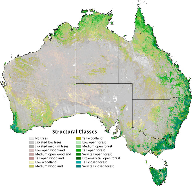
TERN AusCover and the Joint Remote Sensing Research Program has been working with Australian and international scientists to generate detailed national maps of vegetation structure (above). The new maps are significant advancement on previous structural classifications of Australian vegetation (below). Click here to access height, cover and structuralclassifications via the AusCover data portal
TERN’s AusCover facility is taking a leading role in working with state, national and international stakeholders to improve access to satellite sensor data and facilitate the generation of products relevant to the Australian environment.Australia is a vast country with a wide range of diverse ecosystems. To gain an understanding of their values in terms of, for example, carbon stocks and biodiversity, and how these change over time, we need to make use of our extensive archive of satellite remote sensing data. By exploiting these data, we can quantify the state of ecosystems, their dynamics and the impacts of different land use and management policies and practices.
In conjunction with TERN AusCover, the Joint Remote Sensing Research Program (JRSRP), which is run out of the University of Queensland, has been working with Australian and international scientists to generate detailed national maps of the structure (height and cover) and biomass of woody vegetation and to construct a National Biomass Library. These datasets and repositories provide essential baselines against which future changes in the biomass and structure of vegetation can be quantified.The team, which includes Dr. John Armston and Dr. Peter Scarth (QLD Department of Science, Information Technology and Innovation and the University of Queensland), Professor Richard Lucas (University of New South Wales), Dr. Peter Bunting (Aberystwyth University, UK) and Dr. Dan Clewley (Plymouth Marine Laboratory, UK) have been collaborating with the Japanese Aerospace Exploration Agency (JAXA) on theirKyoto and Carbon (K&C) Initiative for over a decade.
They found that by combining  data from the Japanese Advanced Land Observing Satellite (ALOS) Phased Arrayed L-band Synthetic Aperture Radar (PALSAR) and Landsat-derived Fractional Green Cover, a unique segmentation of the Australian landscape could be obtained, with individual segments representing areas that have, relatively, the same vegetation structure.
By then classifying segments and associating these with structural metrics obtained from ICESAT Geoscience Laser Altimeter System(GLAS) data, the height of vegetation could be characterised. When integrated with cover information, this provided the basis for a new structural classification of vegetation across Australia.
“These new height and cover products have been combined to provide a significant advancement on previous structural classifications of Australian vegetation,” says Dr. John Armston.
“Prior to this, we only had national maps of vegetation structure at a scale of one to 5 million that were made back in the early nineties. The new map products will help to increase the reliability of national environmental reporting.” The height, cover and structural classifications are now available through the TERN AusCover data portal.
TERN AusCover is also making the landmark National Biomass Library available for public release on 14 April 2016. This library has been constructed by methodically collating tree-level data from a plethora of on-ground vegetation surveys conducted by multiple organisations throughout the country, including TERN’s Australian SuperSite Network.
The biomass of each tree has then been estimated using a suite of allometric equations developed by CSIRO’s Keryn Paul and Steven Roxborough and estimates for each plot have been scaled to a per hectare level. The library has taken data from over 15,000 plots located in all states, with these comprised of over 1 million measurements of the diameters of individual trees.
Professor Richard Lucas has been impressed by the willingness and enthusiasm of the contributors and stated that: “We’d like to thank all the organisations involved in providing their data to a national resource, without which we wouldn’t be able to deliver remotely sensed products”.

The National Biomass Library has been constructed by collating data from a plethora of on-ground vegetation surveys conducted by multiple organisations throughout Australia (above) and is vital to the mapping and measuring of Australia’s biomass, inclduing the high-biomass tall eucalypt forests of Tasmania (below – image courtesy David Mannes, Forestry Tasmania). The National Biomass Library will be available on 14 April 2016 via the TERN AusCover data portal
The data in the Biomass Library are being used by TERN AusCover through the JRSRP to generate Australia’s first national high-resolution (25 m) map of above and below ground biomass from ALOS PALSAR, Landsat and ICESAT GLAS data. The data will also contribute to the development of global map products, such as those proposed under ESA’s GlobBiomass project.The National Biomass Library is not a static product and will continue to get updated as new on-ground vegetation data, collected by individuals and organisations, is uploaded to the Biomass Library. “Not only will people receive consistently derived biomass estimates but they will also contribute to the retrieval of biomass and structural attributes from the future satellite sensors that have been designed specifically for this purpose and contribute to models dealing with carbon budgets,” said Professor Lucas.
Professor Lucas emphasised the importance of the Biomass Library and resulting maps of biomass. “The new data map will provide a baseline estimate of carbon stocks for Australia against which changes can be quantified using existing and forthcoming satellites including JAXA’s ALOS-2 PALSAR-2, the US National Aeronautics Space Administration’s (NASA) Global Ecosystem Dynamics Investigation (GEDI) and the European Space Agency’s (ESA) BIOMASS mission.
“The Biomass Library is essential to the development and validation of these maps. By progressing methods for detecting biomass change, we will be able to better understand and quantify the impacts of land clearing, regeneration and fire, informing the development of policy and land management strategies,” said Professor Lucas.
The release of the new vegetation structure and biomass maps and the National Biomass Library through the AusCover data portal marks a significant step forward in understanding how vegetation structures and biomass vary across the country and provides information that can be used to quantify the impacts of change.
Many new areas of research and applications in management are anticipated following the release of these products, which will be regularly reviewed and updated as more information and data become available. The data are also provided to support government agencies responsible for meeting national reporting requirements under the framework of, for example, the United Nations Framework Convention on Climate Change (UNFCCC) and the Convention on Biological Diversity (CBD).
The information will further contribute to meeting challenges associated with environmental change, including climate impacts, loss of biodiversity, impacts of bushfires, and deforestation and degradation. As pointed out by Professor Lucas, “the better we can observe what’s happening to our ecosystems, the better we can understand the underlying processes that drive change—and the more effective we will become at managing the land sustainably, restoring environments and responding to the uncertainties arising from a rapidly changing global environment”.
- If you would like to contribute to the National Biomass Library, please contact Richard Lucas or John Armston
- The National Biomass Library will be available on 14 April 2016 via the TERN AusCover data portal. The release of the library will be announced via the TERN website and on Twitter (@TERN_Aus) and Facebook.
Original article published in TERN newsletter, April 2016 (Link)