
Above and Below: Understanding River-Groundwater Exchanges

Why is it important to understand the interactions between surface water and groundwater?
Interactions between surface water and groundwater are of vital importance for many water resources management issues including the provision of safe drinking water, the fate of micro pollutants in the hydrological cycle, and ecological processes, as well the implications for groundwater dependent ecosystems and the efficiency of river restoration projects. Understanding the exchange of water and chemicals between rivers and groundwater—in what direction, how fast, and the critical variations in both space and time—are absolutely fundamental for hydrologic science, management and policy.
What are the challenges of studying these interactions?
The interactions between rivers and underlying groundwater are not only complex but also difficult to observe for a variety of reasons. For example, streambeds are heterogeneous and constantly changing as a result of erosion and deposition processes [Partington et al., 2017] Also, flow processes on the surface and in the subsurface have very different temporal dynamics and follow different physical laws. Furthermore, surface water and groundwater interactions occur across a wide range of different spatial and temporal scales so measuring these “exchange fluxes” is highly scale dependent.

Schematic representation of an anthropogenically modified catchment illustrating river water and groundwater interactions. Technological advances and modelling approaches are improving our understanding of the surface (e.g., through drones), the subsurface (e.g., hydraulic observations of water table dynamics or hydraulic properties of the streambed and its conceptualization in numerical flow models), and exchange fluxes between the surface and subsurface. Credit: Brunner et al., 2017, Figure 1
What methods are used to measure these interactions in the field?
A variety of methods are available, each suitable for a given spatial and temporal scale, but they fall into two broad categories: hydraulic methods and tracer based methods.
The greatest advances in measurement approaches have been achieved using tracer based methods which exploit the fact that surface water and groundwater often have different electrical conductivity or concentrations of dissolved gases such as radon or oxygen. Application of these methods has been limited by available measurement technologies but some significant breakthroughs have been achieved. For example, a portable mass spectrometer has been developed that allows the continuous measurement of partial pressures of gases such as krypton, oxygen, carbon dioxide, neon or nitrogen in real time [Brennwald et al., 2016]. This is a very significant advance compared to the traditional approach of obtaining a sample in the field and sending it to a specialized laboratory.
Other approaches, such as automated or semi-automated sampling devices, allow the continuous measurement of factors such as pH, temperature or electrical conductivity which further help to quantify important exchange fluxes.
What insights can be gained from new technologies?
Several new approaches to characterize the geological and morphological properties of streambeds are now available, many of which were developed for applications outside the field of hydrology or hydrogeology.
For example, the latest generation of medical computed tomography scanners allows a high-resolution three-dimensional reconstruction of samples.
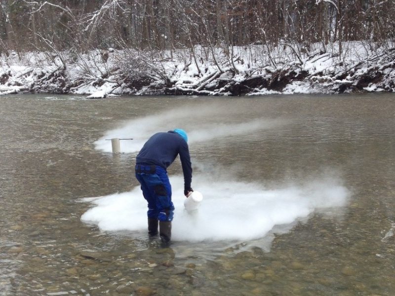
Liernur et al. [2017] combined such tomography technologies with freeze coring in which the subsurface is frozen around a hollow lance using liquid nitrogen. A sample can be extracted with minimal disturbance.
The combination of freezecoring and tomography affords unprecedented insights into the fine-scale structure of streambeds (see image below).
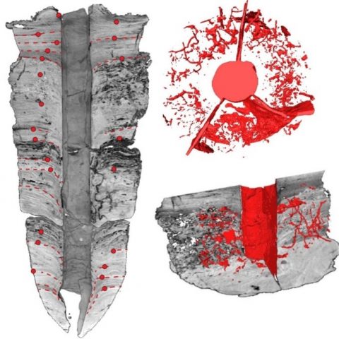
Scan of a freezecore. The left image shows a vertical cross-section (height: 60 cm, width: 20 cm) which allows identifying the areas that have been influenced by ramming in the lance into the streambed. The images on the right show pores with a diameter above a certain threshold of the same freezecore. The top image is a view from above; the lower image is a vertical subsection. Credit: Modified after Brunner et al., 2017, Figure 2; original source Liernur et al. [2017] left image, Liernur [2016] right images
Several new approaches to characterize the geological and morphological properties of streambeds are now available, many of which were developed for applications outside the field of hydrology or hydrogeology.
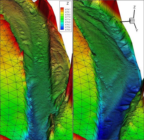
Stream topography before and after a floodvevent acquired through a UAV. The images show a section of 500m length, 250m width. Credit: Brunner et al., 2017, Figure 3
Meanwhile, developments in sensor technology and unmanned aerial vehicle (UAV) systems open a range of new possibilities for rapid image acquisition and the mapping of rivers and their floodplains.
Traditional airborne platforms such as planes or helicopters are typically very expensive and require careful planning, making it difficult to capture highly dynamic events such as floods. UAVs, on the other hand, can be deployed at very short notice.
Photogrammetry using UAVs or LiDAR- sensors mounted on UAVs now enable high-resolution digital terrain models of floodplains to be generated (see image left).
There are a range of other applications of UAVs too, such as obtaining grainsize distributions of the floodplain. Such information can be combined with measurements of physical properties and, in combination with geostatistics, can provide useful information for the development of geological models of the streambed.
What do numerical models contribute to our understanding?
While field studies across a wide range of temporal and spatial scales have improved understanding of the physical environment, it is essential to integrate these into numerical models. Numerical modelling approaches are a way to explore, conceptualize, quantify, and predict complex interactions, fluxes and feedback mechanisms. Numerical models also provide a quantitative framework for integrating the available information on exchange fluxes and streambed structure.
How can field observations complement modelling approaches?
Modelling and field observations go hand in hand. In principle, numerical models can simulate the interactions between the surface and subsurface in a holistic and physically based way. However, the full potential of these models is far from realized due to the lack of data required to parameterize and validate such models. For example, most streambeds are highly variable and dynamic. The current conceptualizations of streambeds employed in hydrologic models do not represent this physical complexity and transience. Field-based measurements of the spatial and temporal distribution of exchange fluxes, to mention just one example, provide crucial information for model conceptualization, parameter estimation and verification.
How can geostatistics be used?
Even when field-based measurements are available, the exhaustive spatial distribution of riverbed properties is never known. Geostatistical methods can be used to model riverbed properties. Multiple equally-likely realizations can be generated and used for uncertainty assessment and hypothesis testing. Traditional two-point geostatistics offer only a limited range of geological and geomorphological patterns, not realistic and too simple. However, newer geostatistical methods—such as multiple point geostatistics—allow the integration of a broader range of data and can be used to model more realistic riverbed properties.
What challenges lie ahead in integrating new field-based and modelling approaches?
One challenge is to link field measurements to what is modelled in meaningful ways and at appropriate spatial and temporal resolution. We need to know exactly how data and models can be compared and then coupled but reconciling such differences at representative scales is difficult.
Another challenge is effectively compiling data from different sources. More and more types of field-based data are now available in ever increasing quantities but knowing which data to use, and when, is a key challenge. We need to find better ways to combine the different sources of information and better insight on the accuracy of the data and the appropriate scales of applications. A further challenge is to optimally merge field-based data with mathematical modelling approaches in a way that honors the complexity of the data. We are not proponents for complexity for the sake of complexity. Clearly finding the appropriate level of data (types, resolution) will depend on the problem being studied and the associated scale of interest. Finding the “sweet spot” poses a challenge in itself.
Finally, a very important challenge is it to understand how we can better learn from systematic deviations between measured values and modelled values as these can point to conceptual and other problems in the model and the theory reflected in the model.
—Philip Brunner and Philippe Renard, University of Neuchâtel, Switzerland; René Therrien, Université Laval Québec, Canada; Craig T. Simmons, Flinders University, Australia; and Harrie-Jan Hendricks Franssen, Forschungszentrum Jülich, Germany; email: philip.brunner@unine.ch
Citation: Brunner, P., P. Renard, R. Therrien, C. T. Simmons, and H.-J. Hendricks Franssen (2018), Above and below: Understanding river-groundwater exchanges, Eos, 99, https://doi.org/10.1029/2018EO091395. Published on 26 January 2018.