
Estimating where our river water goes
Of the water that makes it into our rivers, how much goes to the landscape, how much goes to the atmosphere, how much is extracted for consumptive use and how much flows out to sea?
The Australian Water Resources Assessment River (AWRA-R) model makes it possible to quantify this for river reaches and whole river systems—taking into account river inflows, current river volume, losses to groundwater, overbank flooding and return flows, and rainfall and evaporation at the river surface.
For example, of the inflows to rivers in the South East Queensland region, two per cent is lost to the atmosphere and landscape due to overbank flows (when rivers burst their banks and spread out onto floodplains). Fourteen per cent seeps to groundwater through the river beds, and about 72 per cent of the inflows make it to the tidal limit of the rivers as freshwater outflows to the sea.
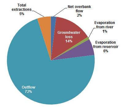
Breakdown of the total runoff into rivers in the South East Queensland region
Knowing where river water goes is useful not only for our understanding of river systems, but also for making accounts for river water at basin, State and national scale. It’s also useful for local surface and groundwater managers to manage their resources. For example, knowledge of the seepage to groundwater could be used to better decide how much water to release from a dam.
The model has helped to significantly reduce the unestimated water amounts reported by the National Water Account. In the Murray–Darling Basin account, the unestimated river water amounts reduced from 12 000 GL to less than 1000 GL in 2016.
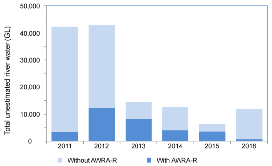
Comparison of unestimated river water for the Murray–Darling Basin region (with and without AWRA-R model estimates)
To-date, the model has been applied to 40 large river basins, within nine of the ten National Water Account regions. Together they cover most of the major developed and populated Australian river regions.
Request the estimated river water balance components from 1970 onwards at reach to river and regional scales by emailing awrams@bom.gov.au. Please also contact us to apply the model in your region.
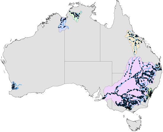
Current coverage of AWRA-R river basins and streamflow gauging sites
Photo: Near Eden, New South Wales. Source: Paul Feikema, Bureau of Meteorology
Original article posted on enGauge, October 2017 (link)