
Evaluating a daily water balance model (AWRA-L) to represent streamflow intermittency
There is a growing interest globally in the spatial distribution and temporal dynamics of intermittently flowing streams and rivers. Previous studies have predominantly relied on the use of gauged streamflow data to make inferences about the distribution of intermittent streams. However, the sparse distribution of stream gauging sites makes it difficult to characterise streamflow intermittency across river networks and the biases in the distribution of stream gauges may also give misleading impressions of spatio-temporal variations in streamflow intermittency within river networks (Figure 1).
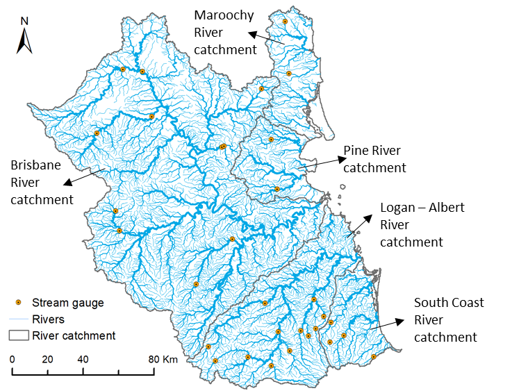
Figure 1. Comparison of the dense river networks and sparse distribution of available stream gauges in south-east Queensland (gauge location data sourced from the Bureau of Meteorology; river network and catchments sourced from Australian Hydrologic Geospatial Fabric).
Alternative methods for quantifying the extent of intermittent flow include citizen observation networks supported by regular reports from trained volunteers; the use of electrical arrays by measuring the electrical conductivity of the streambed; development of predictive models for intermittent streams, and deployment of unmanned aerial systems. These alternatives are generally appropriate over small spatial extents and short time frames but are difficult to scale up to larger areas to quantify flow intermittency in space and time. Satellite remote-sensing-based quantification of flow intermittency can cover larger spatial extents but for now remains applicable only to relatively large rivers (> 30 m in the case of Landsat imagery) and can be affected by factors such as vegetation and cloud obstruction.
Spatially contiguous runoff data derived from water balance models can be used to generate spatially explicit estimates of streamflow (thus flow intermittency), and provide another potential alternative to quantify spatio-temporal variations in flow intermittency. Our previous study (Yu et al, 2018) applied runoff simulations from a water balance model to quantify catchment-wide flow intermittency, but only at a relatively coarse monthly time step. Simulations of a finer temporal scale (e.g. daily) are necessary to capture the dynamic aspects of hydrological processes and to better understand the causes of flow intermittency at multiple spatial scales.
We recently took a further step to use the Australian Water Resource Assessment Landscape (AWRA-L) model, a daily water balance model developed by CSIRO and the Bureau of Meteorology, to quantify spatially explicit estimates of flow intermittency in eastern Australia over long timeframes (1911 – 2016) (Yu et al. 2020). We also evaluated the effect of model time step (daily vs. monthly) on flow intermittency estimation to inform future model selection.
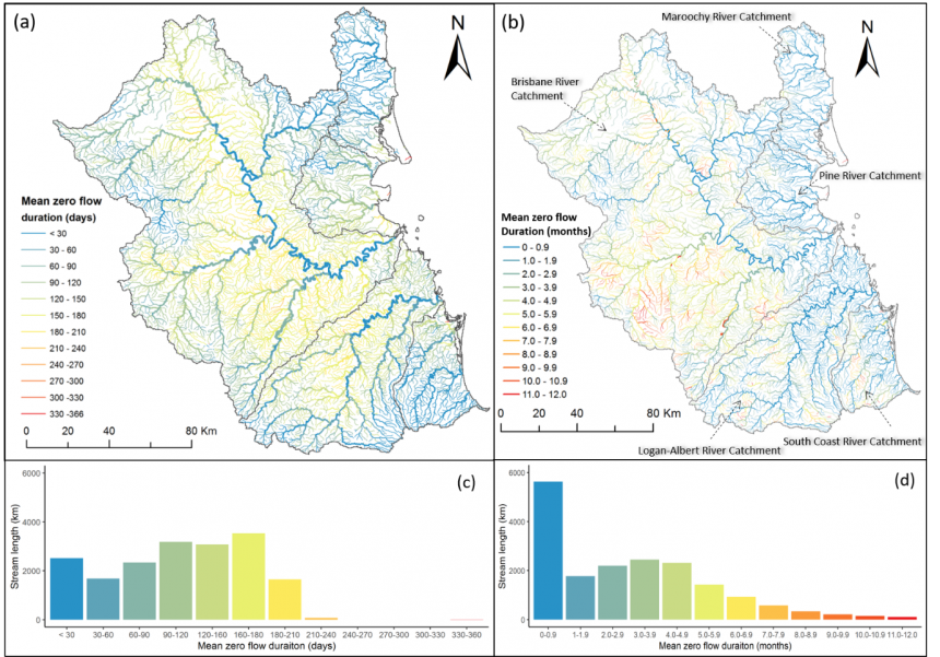
Modelled patterns of flow intermittency in eastern Australia revealed highly dynamic behaviour in space and time (Figure 2), with zero-flow events affecting 29% – 80% of the river network over 1911-2016, using the AWRA-L model. The daily flow model did not perform better than the monthly flow model in quantifying flow intermittency at a monthly time step, and model selection should depend on the intended application of the model outputs.

Figure 2. Comparison of the spatial pattern of average annual flow intermittency in South-east Queensland derived from (a) daily flow simulations from the AWRA-L model and (b) monthly flow simulations from the WaterDyn model. Stream segments in both figures are coloured using the same frame but different units. Line thicknesses show the stream orders. Frequency distributions of variations in the total stream length for each of 12 flow intermittency classes are also shown for (c) the AWRA-L model and (d) the WaterDyn model.
This study not only confirmed that intermittent flow conditions prevailed in the majority of streams in south-east Queensland, but also provided more detailed information on their spatio-temporal variability at a daily time step. Our general approach to quantifying spatio-temporal patterns of flow intermittency is transferable to other parts of the world, and it can inform hydro-ecological understanding and management of intermittent streams where limited gauging data are available.
References:
Yu, S., Bond, N. R., Bunn, S. E., Xu, Z., and Kennard, M. J. (2018). Quantifying spatial and temporal patterns of flow intermittency using spatially contiguous runoff data. Journal of Hydrology, 559, 861–872, https://doi.org/10.1016/j.jhydrol.2018.03.009
Yu, S., Do, H. X., van Dijk, A. I. J. M., Bond, N. R., Lin, P., Kennard, M. J. (2020). Evaluating a landscape-scale daily water balance model to support spatially continuous representation of flow intermittency throughout stream networks. Hydrology and Earth System Science, 24, 5279–5295. https://doi.org/10.5194/hess-24-5279-2020