
New hydromorphological dynamics dataset for all Australian river reaches
Hydromorphological attributes such as river width, flow regime, water extent and gradient provide fundamental information for understanding river hydrological, biogeochemical and ecological processes in floodplain-river systems, identifying flooding-prone areas, assessing river conveyance capacity, estimating river depth and discharge, describing river width features in hydrological modelling, and determining potential locations for satellite-based river gauging. For instance, detailed data on river characteristics is required to improve river routing in many state-of-the-art hydraulic and hydrologic models, as model development moves toward higher spatial resolution and larger spatial scale. Although there are some river width datasets at regional and global sales, none provide temporal variability of river width.
In our recent paper published in Earth System Science Data we developed an approach for estimating spatial and temporal river width dynamics by using a 27-year time series of 25 m resolution Landsat-derived surface water extent maps from Water Observations from Space (WOfS), created by Geoscience Australia, and Geographic Information System (GIS)-based hydrological features from Australian Hydrological Geospatial Fabric (Geofabric), produced by Bureau of Meteorology. We also proposed a parameter γ to classify river reaches by the degree to which flow regime tends to ephemeral, intermittent, frequent or permanent. River gradient was calculated based on the 1 s DEM, an elevation data product developed by Geoscience Australia using the Shuttle Radar Topography Mission (SRTM) data.

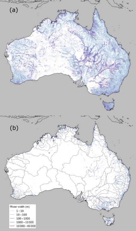
Figure 1 Maximum (a) and minimum (b) river width across Australia; 218 river regions delineated in grey in (b).
Our hydromorphological dataset provides river width at different recurrence frequencies, flow regime (γ) and river gradient for 1.4 million Australian river reaches. As Figure 1 shows, there are large differences between maximum and minimum widths across Australia. Most river reaches are ephemeral while the (semi-) permanent rivers are distributed along the northern and eastern coasts. Numerous river reaches in the interior Lake Eyre Basin, in the tributary catchments of the Murray–Darling Basin, and along the Gulf of Carpentaria have very broad maximum widths with ephemeral flow patterns (Figure 1). The total reach length over Australia decreases by a factor of 21 as recurrence frequencies increase from 0.5% to 80%, and the majority of river widths range from 25 m (limited by the spatial resolution of Landsat imagery) to 250 m irrespective of recurrence frequency. The dominant flow regime for Australian rivers is ephemeral or intermittent (γ = 0.1-0.6).
The new data are available from the National Computational Infrastructure (NCI) THREDDS Data Server. The data are in ASCII format, which can be downloaded and easily combined with the Geofabric product in ArcGIS or QGIS, along with other Geofabric data, such as flow direction, river length, hierarchy (major or minor rivers), and feature type (nature, artificial, or water area flow segment), etc., for different kinds of applications.
Paper: Hou, J., van Dijk, A. I. J. M., Renzullo, L. J., Vertessy, R. A., and Mueller, N.: Hydromorphological attributes for all Australian river reaches derived from Landsat dynamic inundation remote sensing, Earth Syst. Sci. Data, 11, 1003–1015, https://doi.org/10.5194/essd-11-1003-2019, 2019.