
Putting Australia’s environmental monitoring sites on the map
The recently released National Environmental Monitoring Sites Register (NEMSR) brings together a diverse range of Australian environmental monitoring networks in one database and on an interactive map.
The NEMSR currently includes rainfall radars, long-term weather observation sites, seismic monitoring stations, flux stations, ground cover reference sites, shelf moorings, and other networks. The smallest network is acoustic pressure from Geoscience Australia (5 sites) and the largest is water monitoring stations from the Bureau’s Water Data Online (3,000+ sites).
NEMSR contains key attributes (metadata) for each monitoring network, and links users to observations. It can be accessed in two ways:
- Select environmental monitoring networks to explore using the NEII data viewer.
- Access it through web service endpoints and embed these in applications and systems.
The Bureau has developed this tool to improve access to environmental information across organisations and domains. Its release in October 2016 is a major milestone of the National Environmental Information Infrastructure (NEII) which aims to improve discovery, access and re-use of environmental information.
When combined with other NEII components, such as the metadata catalogue and web data services, the NEMSR will provide a richer way to discover environmental information.
Become a data provider through the National Environmental Monitoring Sites Register or contact us.

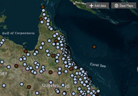
Water Data Online (blue) and the Australian Climate Observations Reference Network – Surface Air Temperature (brown) sites shown on NEII data viewer