
The best method for automated water detection
Recent work by Dr Adrian Fisher and his colleagues describes the comparison of seven different water index methods for automated water classification in eastern Australia, using near coincident high-resolution imagery as reference. A new Landsat water index developed by the Joint Remote Sensing Research Program (JRSRP), which is simple to calculate from imagery corrected to surface reflectance, achieved the greatest overall accuracy.
According to Dr Fisher “The automated detection of surface water in Landsat satellite imagery is becoming popular, with many research projects looking to investigate the spatial and temporal dynamics of water using the global archive made available by the USGS.”
For the state government partners of the JRSRP the main interest is in classifying water, so it can be masked from subsequent analyses that focus on the dynamics of vegetation structure. Both applications require accurate water detection, although determining the accuracy of automated large area Landsat water classifications is difficult.
A further insight from the paper came from the use of high-resolution reference data for model accuracy assessment.
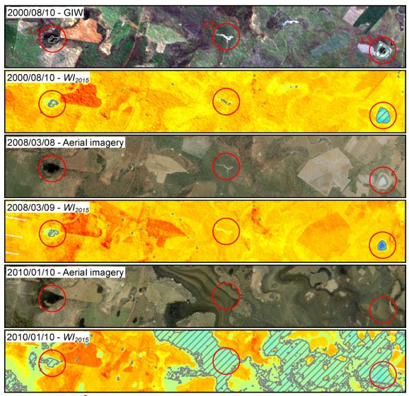
“In addition to determining the relative accuracy of the different methods, the use of high-resolution reference data enabled the research to analyse the influence of sub-pixel water components and water colour on classification accuracy. For example, although all the methods achieved overall accuracies of 95–99% for pure pixels, they only achieved 73–75% for mixed pixels. Omission of these mixed pixels and of water that was green-brown in colour means that water area was generally underestimated.” said the authors.
The work recommends that this information on the influence of sub-pixel water components and water colour should be considered when using Landsat-derived surface water maps in other research, such as flood modelling or water connectivity analyses.
The paper also includes the validation dataset as supplementary material, in order that others working on methods of detecting surface water in Landsat imagery can easily compare their results to ours.
Visit here for further information on the JRSRP
‘Comparing Landsat water index methods for automated water classification in eastern Australia’, Remote Sensing of Environment, doi:10.1016/j.rse.2015.12.055