
Unique river systems demand unique models
A new satellite-based river modelling technique can account for the unique dynamics of individual water bodies.
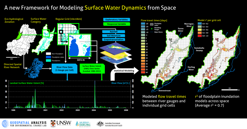
Models using Earth observation data to predict surface water availability and extent provide useful tools for sustainable management and restoration of terrestrial surface water resources. A recent study by Valentin Heimhuber and his colleagues provides a new technique for satellite-based modelling of surface water and inundation dynamics (SWD) that can account for the unique dynamics of hydrologically distinct surface water bodies.
The researchers, based at the at the Geospatial Analysis for Environmental Change lab, used a unique Landsat-based time series of surface water extent (1986–2011) to statistically model SWD as a function of river flow and spatially explicit time series of soil moisture, evapotranspiration and rainfall.
They developed an innovative spatial modelling framework, which allows modelling SWD over large areas separately for hydrologically distinct floodplain, floodplain-lake and non-floodplain areas within eco-hydrological zones and 10 x 10 km grid cells (see below).
The team applied this modelling framework to three hydrologically distinct sub-regions (Lower-Murray, Murrimbidgee, Paroo) of Australia’s Murray-Darling Basin (MDB) and modelled SWD through periods of flooding and drying on 233 (64%) out of a total of 363 floodplain units with an average r2 ≥ 0.6.
The contribution of rainfall, evapotranspiration and soil moisture to the models’ predictive performances differed among the three sub-regions, with the highest contribution in the least regulated and most arid sub-region (Paroo, see figure above).
“Our study provides a highly-automated and data-driven approach for modelling SWD that can be applied to other large river basins across the world. Satellite-based data products are becoming available for more and more areas and our models represent cost-effective tools for using these time series to improve the management of limited surface water resources.” said the authors.
The researchers are currently applying this framework to model SWD across the entire MDB, also incorporating MODIS data to improve the ability to capture rapid changes in SWD associated with flooding events.
Article: ‘Modeling 25 years of spatio-temporal surface water and inundation dynamics on large river basin scale using time series of Earth observation data’, Hydrology and Earth System Sciences, doi: 10.5194/hess-20-2227-2016