Long-term streamflow trends at Hydrologic References Stations

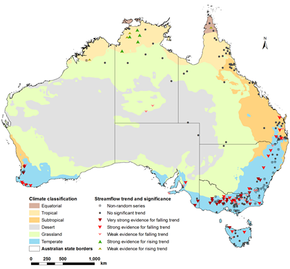
Analysis of streamflow trends around Australia—using the Bureau’s Hydrologic Reference Stations —reveals just nine sites with an increasing annual streamflow trend, while 72 sites show a decreasing trend and the remaining sites show no trend.

Decreasing trends were also found in seasonal streamflow, high and low streamflow and groundwater discharge, except in the Northern Territory and northern Queensland.
The Hydrologic Reference Stations network includes 222 high quality monitoring sites used for identifying long-term trends in streamflow variability and predicting the effects of climate variability on streamflow across all Australian hydroclimate regions.
Updated recently with data from the past two years, an investigation into long-term streamflow reveals that trends vary according to location and season.

Streamflow trends identified through the Bureau’s Hydrologic Reference Stations.
Sites in the Northern Territory and northwestern Western Australia show an increasing annual streamflow trend. However, most stations in southeastern Queensland, New South Wales and Victoria show a significant decreasing trend. Approximately half the stations in southwestern Western Australia also show a decreasing trend. No significant annual trend was seen in South Australia, northern Queensland, most of Tasmania, or a small number of stations in central Australia.
Most of the Northern Territory and central Australia show increasing trends in summer streamflow, while no stations show increasing trends for winter flow.
Each of the Hydrologic Reference Stations has more than 30 years of streamflow data, and represents catchments with minimal land use change and river diversions. This means we can be confident that the trends we are seeing are due to climatic influences alone.
Explore streamflow trends with Hydrologic Reference Stations
Article originally posted on enGauge (BOM) website, December 2015 (Link)
