
AWRA-L Community Modelling System released, hands-on training available
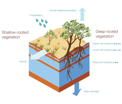
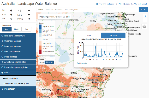 The Australian Water Resource Assessment Landscape (AWRA-L) Model is a 0.05° (approximately 5 km) gridded daily water balance model developed by CSIRO and the Bureau of Meteorology for Water Resource assessment purposes (see Hafeez et al., 2015; Viney et al, 2015; and Van Dijk et al., 2010 for the model description). Since 2015, the Bureau has taken the system into operational use and now it produces estimates of runoff, soil moisture, evapotranspiration and deep drainage from 1911 until yesterday, with outputs available to the public through the Bureau’s Australian Landscape Water Balance website (www.bom.gov.au/water/landscape).
AWRA-L model outputs are already widely used by state and commonwealth water and agriculture agencies for water resource assessment and planning, agriculture and natural resource management, flood applications and groundwater modelling applications across Australia.
What is the AWRA-L Community Modelling System?
The next exciting step for the Bureau is the development and release of the AWRA-L Community Modelling System. The release of the AWRAMS as a community model provides the best means to engage the most qualified experts in each discipline in the process of refining and applying AWRA MS to these modelling applications.
The AWRA-L Community Modelling System will be made broadly available free of cost to the modelling community for research and project work in November 2016. The release will initially be limited to the grid-based Landscape (AWRA-L) model related functionality, including the core simulation system as well as the AWRA-L related calibration, visualisation and benchmarking functionality supported by standard datasets. The license agreement allows free use and modification for non-commercial purposes.
Hands-On Training
In conjunction with this release, the Bureau is undertaking introductory hands-on training workshops on the use of the AWRA-L Community Modelling system. The first of these is planned in Canberra on the afternoon of 13 December 2016, ahead of the subsequent 2016 OzEWEX annual workshop. This half-day introductory workshop will cover:
- An overview of the AWRA Modelling system (history, how it is used, why a community system)
- An introduction to the Science of AWRA-L (conceptualisation and technical evaluation)
- An introduction to the Community Modelling System Jupyter (Python programming language based) Notebooks covering:
- AWRA-L simulation and visualisation
- Extraction (grid, point and shapefile based) and temporal aggregation
- Calibration of AWRA-L to a single catchments data
- Evaluation of AWRA-L against streamflow and other benchmarking data
- Worked example of model and calibration for a single catchment
- Collation of input data
- Altering the model
- Setting the objective function and Calibration
- Simulation and evaluation against observations /prior AWRA-L parameterisations
Workshop participants are expected to bring their own laptop. The software will be provided for installation in advance following acceptance of the license agreement. No previous user experience with Python coding is necessary. A session will be held immediately prior to the workshop to work through any installation issues.
To register, workshop participants should indicate their interest by sending an email to awracms@bom.gov.au before 28 November 2016.