Varying catchment model parameters over time to reflect land use change

Hydrologic models are the most important tools for decision makers and scientists to assess water resources availability, risks due to flooding and the health of our waterways. Improving our hydrologic modelling toolbox remains a critical research area, with much to be done. For instance, hydrologic modelling has so far progressed under the assumption that catchment conditions do not change over time. One calibrates model parameters and then assumes these are valid in the future. However, this is rarely likely to be the case, especially for catchments that may experience land use change – be it anthropogenic change such as deforestation for agricultural use or natural changes due to bushfire. A rethink of the traditional calibrate-validate methodology is needed in order to provide meaningful and accurate hydrologic predictions in such catchments.
What is required is a modelling framework that is dynamic, in that the model itself can change with time according to changes in catchment conditions. Of course, it is possible to manually re-calibrate a model whenever the modeller is made aware of a change to catchment conditions. A more elegant approach would be to develop a modelling framework that is capable of automatically adjusting itself in a sensible way. For instance, by relaxing the assumption that model parameters should be constant in time, it would be possible to model a wider range of potential land use conditions and hydrologic processes in a seamless manner.
In a previous study, we developed a sequential data assimilation to achieve this. Model parameters are automatically adjusted based on signals of change present in observations of the catchment (e.g. streamflow or soil moisture measurements), without requiring any input from the user about land use change. The model parameters that are most strongly correlated with the observed variable are adjusted, taking into account the uncertainty in both the observations and the model predictions. For example, consider the case of a small catchment that is rapidly and extensively deforested, which we examined in another recent study. Streamflow measurements indicated a substantial increase in surface runoff volume due largely to the reduction in moisture uptake by vegetation. Our method accordingly reduced the infiltration parameter (often assumed related to vegetation water uptake), along with other conceptually meaningful parameter adjustments. Furthermore, the method can be used in both reanalysis and forecasting mode as it is capable of adjusting the model parameters in real time as observations become available.
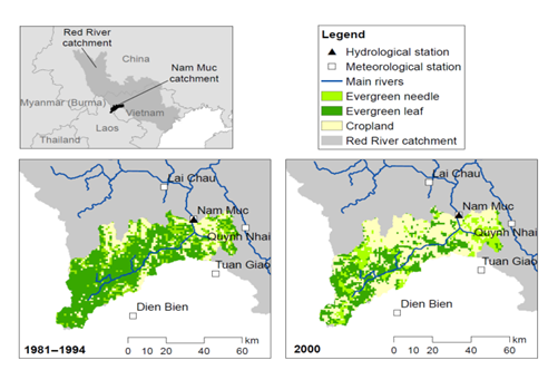
Our latest publication in Hydrology and Earth System Sciences goes beyond this work to examine the performance of the proposed method in a more complex but realistic setting. How successful is the method when the land use changes are more gradual, and the impacts on hydrologic variables more subtle? How important is the choice of the model structure in determining the success of the time-varying parameter method? These are important questions that must be addressed in order to make the time-varying parameter method useful for real applications. Our experiments for the Nam Muc catchment in Vietnam gave the first evidence that the method can provide meaningful and accurate predictions in realistic catchments with land use change, so long as a flexible model structure is chosen from the beginning. This means that the model (and the feasible parameter space) must encapsulate a sufficiently wide range of hydrologic processes since future land use is essentially unknown. One could argue that more physically realistic models may be one way to achieve this. Our research shows that even conceptual models that can adequately model a wide range of catchment types can be useful. Ultimately, we must continue our efforts to develop more sophisticated models that will cater to such applications.
Study catchment showing gauges and changes in land cover over time.
Article: “Time-varying parameter models for catchments with land use change: the importance of model structure”, Pathiraja, S., Anghileri, D., Burlando, P., Sharma, A., , Marshall, L., Moradkhani, H., Hydrol. Earth Syst. Sci., 22, 2903–2919, 2018, doi.org/10.5194/hess-22-2903-2018

