
Long-term satellite data for managing land and resources
More than 35 years of satellite-derived time-series biophysical map products are now freely accessible via TERN AusCover. Capturing seasonal, episodic and historical changes in land-cover along with the impacts of extreme events, the data are an invaluable source of information for Australia’s environmental management industry and are already being used by researchers and state and federal government programs on a routine basis.
TERN gives researchers and managers better access to environmental data at the scales they need. The network provides more effective and efficient ways for scientists to collaborate, share data and produce research; and delivers the means for data to be collected, stored, published, and shared in consistent ways.
The use of satellite-captured data, along with the field data used to calibrate and validate these products, which are curated and made openly-accessible by TERN AusCover, by managers and government programs to help make better land-use decisions—and protect the environment—is just one example of what is possible when such a coordinated national approach, supported by TERN’s infrastructure, is adopted.
AusCover now delivers freely accessible nation-wide satellite-derived time-series biophysical map products including: ground cover, burnt-area history, vegetation indexes, phenology, and fraction-absorbed radiation.
The data covers more than 35 years and captures historical changes in land-use, land-cover dynamics and the impacts of droughts, bushfires and climate variability in both natural and managed ecosystems.
 |
 |
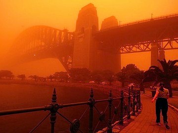
| Few of us could forget the dust storm in September 2009, which famously blanketed Sydney in a bright orange hue. The urban costs of this storm were estimated at $300 million. TERN’s AusCover Facility and its partners are working to mitigate the impacts of such dust storms (Photo courtesy The Age). | Ground cover estimates from fractional cover data available via the AusCover data portal. Blue and red areas means ground is exposed and more at risk of erosion and green areas covered by vegetation. |
“AusCover has compiled the science and methods needed to ‘unlock’ and curate these key datasets so they are more useful for researchers and on-ground environmental managers,” says AusCover’s director, Dr Alex Held.
The datasets have been analysed and processed as time-series across the whole continent, rather than one time-slice at a time, making them more useful for comparing land changes over time.
“This has only been possible by working across boundaries and finding clever ways to harmonise and cross-calibrate data from different satellites, often owned by different nations, and integrate them with field data,” says Alex.
The data are an invaluable source of information for Australia’s environmental management industry and are already being used not only by ecosystem researchers, but also more and more by state and federal government programs on a routine basis, as part of Natural Resource Management (NRM) and other legislated environmental mapping and monitoring programs.
The international science community is also increasingly using the data for global and multi-national NRM projects.
A couple of examples show the scope of how AusCover’s provision of these data is helping people make better land-use and environmental management decisions—and filling important information gaps that other global data products failed to cover.
Phenology data products from AusCover are providing end-users with a characterisation of how different parts of Australia’s land-cover is growing and developing with the change of seasons—vital information for anyone also in the agricultural and horticultural industries.
The product uses high-temporal resolution satellite technology (courtesy of NASA’s Terra and Aqua satellites) to quantify vegetation life cycle dynamics and analyse how these are influenced by seasonal and inter-annual variations in climate.

The Australian Phenology Product—a characterisation of how different parts of Australia’s land-cover is growing and developing with the change of seasons—is just one satellite derived products now openly-available for download via TERN AusCover’s data portal
Ground cover mapping from AusCover provides vital information to help assess soil condition and land-management targets. It is produced using MODIS imagery analysed by CSIRO and validated with field site information collected by project partners, including TERN’s AusPlots facility.
The Australian Bureau of Agricultural and Resource Economics and Sciences (ABARES) is working with AusCover, CSIRO, and state agencies to provide regular updates of the area or ‘fractional cover’ of live and photosynthetically active (green) vegetation, dry or dead vegetation, and bare ground across the Australian continent. This is then picked up by data users such as theCommunity DustWatch program to assess where there might be sources of dust.
Do wildfire experiences influence views on climate change?
ABARES plays a key role in collating and coordinating land use and management information from across Australia but its systems are not designed to work with the large quantities of data that this involves. So, thanks to AusCover’s data management infrastructure, ABARES and its partners are now better able to share data, and ultimately help manage Australia’s agricultural lands more sustainably and productively.
AusCover’s data management infrastructure has more than a petabyte (1,000 terabytes or 1,000,000 gigabytes) of computer storage to allow for complex analyses across the full 30+year satellite archive.
To improve processing and storage efficiencies, data, and their scientific background and comprehensive metadata, are now increasingly stored by AusCover on super-computers or cloud-based systems, through partnerships with such organisations as the National Computational Infrastructure.
The snapshots throughout this article illustrate the range of TERN’s influence in facilitating improvements in the management of Australia’s natural and managed environments. Such improvements help TERN deliver greater returns on public investment in Australian environmental science and natural resource management.
And, they give policy makers and environmental managers a better footing on which to make decisions, including on threat abatement and adaptation to climatic changes.
- To access the data provided by AusCover head to their website:http://www.auscover.org.au/
- For more information on the projects covered in this article please contact AusCover’s Director, Dr Alex Held.
Article originally posted on TERN website, September 2015 (Link)