
Monthly Water Update
Rainfall and streamflow are intrinsically linked, and the Bureau’s new Monthly Water Update will provide you with a quick overview of the recent status of both.
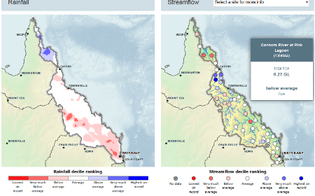
Each month the Update provides a snapshot of streamflows for the past month. Rainfall is a key driver of streamflow and is shown alongside flows from over 220 gauging stations across Australia’s topographic drainage divisions.

Screen shot from Monthly Water Update showing rainfall and streamflow observations side-by-side.
Gauging stations for the Update have been selected to show the spatial variation of flows across drainage divisions.
Gauges were selected which have:
- ongoing operation; and
- largely complete records from July 1980.
Most of the data comes from gauges in the lower reaches of the main rivers in each drainage division, as this provides a view of total outflow from each river. In larger catchments, additional gauges represent the lower, middle and upper tributaries to show the varying status of streamflows in these catchments.
The Update is unique in its consistent presentation of information on rainfall and streamflow across Australia in terms of the past.
The Update uses standardised data analysis and ranking techniques to help water resource managers, primary producers, policymakers compare streamflows over time and between different river systems.
Check out the latest Monthly Water Update
Original article posted on enGauge, Bureau of Meteorology (Link)