
Satellite soil moisture data help understand ecohydrology in the Outback
When assessing vegetation water availability and growth in the Channel Country, remotely sensed soil moisture is more useful than precipitation data, a new study published in ‘Remote Sensing’ found.
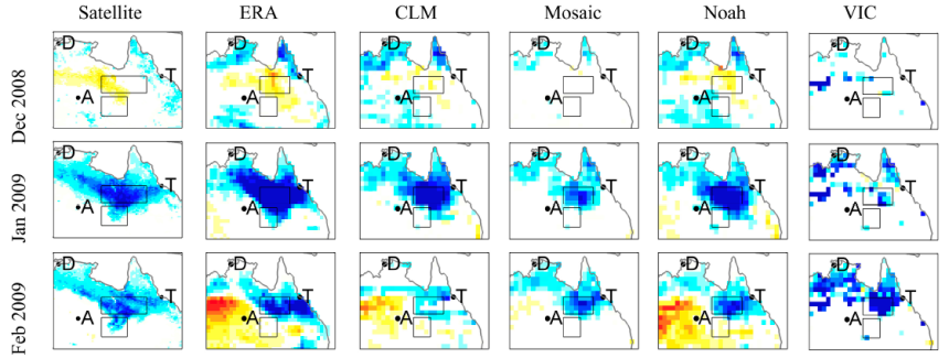
For much of Australia water availability is a primary constraint on vegetation growth. A new study by an international team of researchers led by Tiexi Chen of Nanjing University of Information Science & Technology investigated ecohydrology in the Channel Country, a large region in the Australian outback that experienced widespread river flooding events between December 2008 to May 2009. The period coincided with exceptionally strong La Niña conditions that yielded high rainfall in eastern Australia due to positive teleconnections with the Indian Ocean Dipole and Southern Annular Mode following a decade-long drought in eastern Australia. In such conditions, differences in fluvial-event vegetation growth and long-term vegetation growth are maximized. The results (summarised in below image) showed that reflective remote sensing related to vegetation growth and open water likelihood are in much better agreement with the microwave soil moisture than with gridded precipitation estimates.
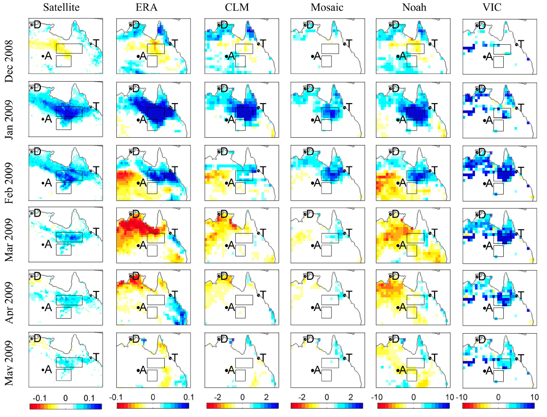
Results from satellite soil moisture, ERA Interim/Land, and GLDAS models (CLM, Mosaic, Noah, and VIC) shown in the columns from left to right. See the codes at the top of each column of panels. The unit of ERA Interim/Land soil moisture is m3/m3, and GLDAS models use the unit of kg/m2.
The output of five state-of-the-art land surface models was also compared and results clearly showed these models still require further development to adequately represent two-dimensional surface water flows.
For hydro-climatologists, this study suggests that the inadequacy of moisture recycling parameterisation in one-dimensional land surface models can be overcome by using microwave soil moisture observations. For hydrologists, this study highlights that important arid-zone process understanding can be gleaned from multiple remote sensing platforms suitable for inclusion in hydrologic and hydraulic model development and evaluation. For eco-hydrologists, the study highlights the importance of soil moisture dynamics on vegetation growth (and associated carbon-cycle dynamics) needs to capture lateral water movement.
In summary, this case study associated with strong La Niña conditions, which can result in standing surface water being the size of several European countries, means that remote sensing of these dynamics is crucial for enhanced understanding of Australia’s hydrology. Finally, this case study seems appropriate as a benchmark for global land-surface model evaluations.
Article: ‘Advantages of Using Microwave Satellite Soil Moisture over Gridded Precipitation Products and Land Surface Model Output in Assessing Regional Vegetation Water Availability and Growth Dynamics for a Lateral Inflow Receiving Landscape’, Tiexi Chen, Tim R. McVicar Guojie Wang, Xing Chen, Richard A. M. de Jeu, Yi Y. Liu, Hong Shen, Fangmin Zhang and Albertus J. Dolman, Remote Sensing, doi: 10.3390/rs8050428