
Spatial scale matters when developing monitoring tools
For the Northern Jarrah Forest (NJF) region of southwest Western Australia, Landsat satellite imagery supports more accurate forest sensitivity analysis than airborne monitoring survey by plane.
Recent work by Dr Niels Brouwers, and his fellow researchers indicates that to develop spatially explicit management tools, careful consideration needs to be given to whether the spatial scale of investigation matches the management area of interest in order to develop a useful management tool.
The study found that the primary reason for the higher accuracy achieved by using Landsat satellite imagery was the opportunity to include a larger forest sample area compared with conducting an airborne monitoring survey by plane.
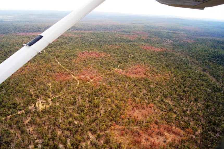
Forest crown dieback and tree mortality caused by the extreme drought and multiple heatwaves in 2010 and early 2011 in the Northern Jarrah Forest region in southwest Western Australia. This drought/heat event was the basis for the study. Photo: George Matusick, May 2011.
When using imagery from the Landsat archive, the larger forest sample area resulted in a better representation of the important landscape-related characteristics of the NJF region, which translated into a higher accuracy of the model estimates and consequently a more useful indicative sensitivity map.
“If you use spatially explicit climate and landscape datasets, you have to make sure that the study sample is representative for the larger management region of interest” said Dr Brouwers.
According to Dr Brouwers, it is clear that the majority of Australia is showing persistent drying and warming trends over the last decades, referring to reports by the Bureau of Meteorology. On top of that, the IPCC predicts more extreme droughts and heat waves for Australia . “It is therefore imperative that spatially explicit management tools are developed to assist in timely climate change adaptation strategies,” says to Dr Brouwers.
The article concludes in saying that the sample bias analysis adopted could routinely be applied for determining an appropriate sample size for spatial studies that aim to provide tools for managers of large forested regions.
The full article can be found here Inferring drought and heat sensitivity across a Mediterranean forest region in southwest Western Australia: a comparison of approaches