
What makes you a good hydrologist?
I know there are many activities in the field of hydrology, including field hydrologist maintaining the gauging network and performing discharge measurements, scientist, model developers and forecasters. I will concentrate on the last group. So what makes you a good hydrologist – forecaster? This is my short subjective not reviewed list of “to do”:
1 – Know your basin
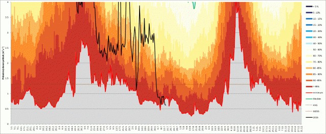
You should learn about the geology, relief, land cover and other specifics of the basin. From my perspective it is the best to combine the librarian study with trips to the landscape. There are always some tricky things about the river and its basin. Let’s have a look at the figure below. You can clearly see a low flow period during the winter and during August, while there are two high runoff periods, one in spring due to snow melting and the other one during October. But wait, why there is high runoff in October? Well this is an area where many large fish pond were constructed from 15th to 17th Century and October is a regular fish harvesting period when large ponds are drained to ease catching of fish. This might be something very obvious, but there are many smaller issues and your ability to correctly imagine what the river valley is like, what the vertical gradient and exposition of the basin is, how much forest and grasslands there are or what might be an artificial effect on runoff are all very beneficial to your understanding of the hydrological processes.

Flow exceedance probabilities of Nežárka River in southern part of the Czech Republic for 1912-2014.
2 – Learn about the statistics, methods and models but think about the water cycle
This seems to be obvious, what else should hydrologists do than study, describe, measure or model the water cycle using statistics, instruments and models. But in a reality, we sometimes tend to work with numbers and forget to think about the process that generates it during the forecasting process.
You do not need to be an expert in Bayesian approaches and Markov chain application but you definitely have to understand statistics, in particular the statistics of hydrometeorological data. As we say in Czech, even being woken up in the middle of the night you must clearly explain e.g. the difference between median and average.
I am fully convinced that every number we get has to be confronted to what we know about the water cycle. Of course you should not end in violating the following rule.
3 – Do not ignore the data
Like Sherlock Holmes always tried to find evidence on the crime scene that consequently led him to build a hypothesis and find the culprit, the data is our evidence for building the hypothesis of the water cycle, runoff generation process and others. (BTW data is also our evidence to reject parts of the hypothesis that proved to be wrong. Even though the negative results are commonly under-evaluated.)
Hydrologists sometimes tend to think too linearly and try to apply expected principles; e.g. the increase of discharge along the stream might be the wrong expectation due to inundation or significant leakage to sediments. I remember July 15th 2002 local downpours that resulted in fast increase of Sazava River with hourly discharges series: 11; 11; 111; 12; 11 (m3.s-1). When the data was checked during the upload to regime database this was evaluated as an error and 111 was corrected to 11. (It is corrected back.)
But on the other hand …
4 – Do not believe the data too much
In my opinion, every forecaster should have at least a short experience in field work. As she mostly works with a raw data in real time forecasting she should know how the data is generated. Have you ever visit a water gauge? I am sure you have. But visitors are often guided to a flag ship station, well sited, well equipped but have you ever seen “normal ” or a “problematic” gauge? Have you ever made field discharge measurement of a flooded natural stream? Believe me every such experience makes you sceptic about the data quality.
Based on previous the next rule has to be:
5 – Use your common sense and indigenous knowledge
One of my old friends and long-time retired colleague once told me that as a forecaster I should not be too afraid if there is hot (>30 °C) weather and cold front comes from west. The reason being that the thunderstorms will most likely move very fast (with lot of wind gust) and will not stay over one place long enough to accumulate rainfall for a serious flash flood. And the rule of thumb works.
During the flood in 2013 our regional forecasting office predicted the discharge of Berounka River to reach 1 500 m3.s-1. This number really scared us. Another indigenous knowledge (an advice from another old retired colleague) is that the peak in Beroun is double the peak in Plzeň upstream. The flow in Plzeň was about to peak at that time at app. 380 m3s-1. So we simply sat down and tried to compute the peak specific runoff from already peaking smaller tributaries between Plzeň and Beroun. We found that for the ungauged rest of the basin the specific runoff needed to be 4 to 5 times higher than for any other observed stream to reach the predicted peak discharge. We therefore rejected the model and made an expert guess prediction of 900 to 1 100 m3.s-1. The observed peak based on real time application of rating curve was 1 100 m3s-1 a post event evaluation was 960 m3s-1.
But you will never be a good hydrologist if you do not…
6 – Love your work.
Original article appeared on HEPEX, 1 September 2015 (link)